 Tweet
Tweet
Originally posted by FJV
View Post
The difference between a GPS fix and one attained by celestial navigation is that the GPS fix is really just like a radar fix on an observable landmark. You know that landmark is there; now you just need to know how far you are from it, so you paint it with your radar. If you are really sexy, you zap it with your fire control radar. Do that with four or more such landmarks and you can get a pretty good fix; ditto with satellites. With a celestial fix, and I'm simplifying things here, you are basically using your Dead Reckoning position, which is purely an estimation based on your expected course and speed over ground, to include set and drift caused by current, as a starting point, and then a trigonometric function of the difference between the height computed of a given star for that time of day and your estimated position on the surface of the Earth, and the actual height observed above the horizon (your sextant shot) of the same star. In other words, you are comparing the position of a star above the horizon taken from the Nautical Almanac for 05:32 AM on August 29th for the general vicinity of the Canary Islands, to your actual sighting of that same star, like Betelgeuse or Aldebaran at the same time and estimated place. The time is important. That chronometer better be gnat's ass accurate or else you will end up in East Jesus. If the height observed is greater, you are closer to your DR position. If the height computed is greater, you are farther away from your DR.
Your fix not being particularly near your DR is not a bad thing. It just means you have to re-calibrate your estimated course, speed, and the set and drift associated with the ocean currents in the area. Once you have a fix, you correct your course and speed if necessary, and start a new track. You get a good fix with five or six observable stars at either twilight or just before dawn when you have a really sharp horizon, you can get a pretty accurate picture of where you are in the greater scheme of things.
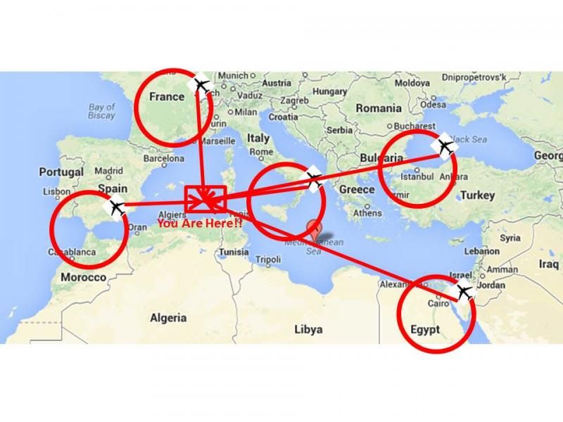
Now, I am assuming that these UAVs might be set up to orbit one or more known landmarks, like a mountain peak, the Eiffel Tower, Old Faithful Geyser, or whatever, so long as it is fixed in space and is not likely to change. If they can maintain their position in an orbit around that known physical landmark, then they might be able to give you their position relative to that landmark, and then your position from the UAV. I threw this graphic below together as an example of how I think it could work. One UAV orbiting Gibraltar, one orbiting the Eiffel Tower, one orbiting Mt. Vesuvius, one orbiting the Great Pyramid at Giza and one orbiting the Hagia Sophia in Istanbul. I have no clue what altitude they'd have to be operating at in order to maintain UHF LOS or whatever, but probably something on the order of angels 70 to 100 I would think. Should be doable regardless as one doesn't have to worry about keeping the SPAM in the can alive. In any event, as I said, the UAV would have to maintain its position relative to that landmark, and then report both its position in terms of both range and bearing, from that landmark, and your straight line distance from the UAV. That just might work.

Comment